Muddy Creek
(The Grand Gorge)
Location: San Rafael Swell
Rating: Basic Canyoneering 2B III
Length: 2-4 hours
Longest Rappel: None
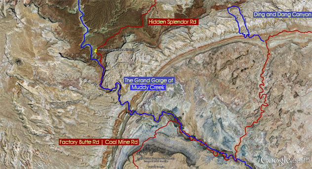
Start: Hidden Splendor Airstrip or Coal Mine Rd | Factory Butte Rd
End: There and Back
Permits: None
Wet Suit: No
Shuttle: No
Overview: Muddy Creek is a 120 mile water way that begins in the Manti-La Sal National Forest and ends when it meets up with the Dirty Devil River in Hanksville. Several canyons shoot off into Muddy Creek and some of the sections of Muddy Creek are wonders to see. The Grand Gorge of Muddy Creek is a short section that offers high 1000 ft walls and a nice creek to follow. The Temple Mountain Rd | Hidden Splendor Rd wanders through Muddy Creek (a tough 4WD – impassable with running water) to meet up with the Factory Butte Rd | Coal Mine Rd.
Approach #1:
From Hwy 24 head west on the Temple Mountain. At the fork in the road take the left fork (Hidden Splendor Rd). After about 4 miles Stay left as you will meet another road coming in from the right (Tan Seep). After about 1 mile, stay left again as you will come to yet another fork in the road. Continue 10 miles across McKay Flat. The next intersection takes you to Tomsich Butte and Reds Canyon on the right, but stay left once more. Follow another 15 miles to the Hidden Splendor Air Strip. The Hidden Splendor Airstrip marks your parking spot. You may attempt to drive down into Muddy Creek and park next to an old miner's shack. Walk the canyon southeast as long as desired.
Approach #2:
From Hwy 24 west of Hanksville, a dirt road (Factory Butte Rd) veers north – approximately 10 miles east of town. Drive this road to Muddy Creek. Follow Muddy Creek upstream to Hidden Splendor Airstrip or distance desired.
View Muddy Creek.kmz in a larger map
 |
 |
 |
 |
 |