Secret Canyon (2BIV)
A+ A- Main ContentLocation: Red Rock Secret Mountain Wilderness, Coconino National Forest
Rating: Basic Canyoneering 2A III or 2B IV depending on conditions
Length: 10 to 18 hours or overnight
Mileage: ~10 miles one way
Longest Rappel: None (bring webbing or short rope for downclimb assistance)
Start: Secret Mountain Trailhead (upper)
End: Secret Canyon Trailhead (lower)
Permits: None. Red Rock Pass required for lower trailhead access
Wet Suit: Not needed
Shuttle: Required for full descent
Overview: Secret Canyon is a long and committing non technical canyon route featuring scenic red rock walls, sections of narrows, vegetation, and occasional pools. This route is best considered an endurance based canyon hike with canyoneering characteristics rather than a technical descent.
The canyon offers a mix of open hiking, light scrambling, and short downclimbs. While no rappelling is typically required, obstacles may require the use of webbing or a short rope for less experienced members of a group.
This route is defined more by its length, navigation, and logistics than by technical difficulty.
Due to its length, remote setting, and complex shuttle logistics, this canyon is a significant undertaking. Most parties either complete it as a long day or break it into an overnight trip.
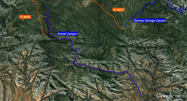
Approach: A shuttle needs to be set up at the end. Form Flagstaff, head south on I-17 to Hwy 89A. Head to Sedona. From Sedona, take Dry Creek Rd north. Dry Creek Rd is on the east end of Sedona. Drive north 2 miles north to Forest service Rd #152 and turn right. Drive another 3.4 miles to the Secret Canyon Trailhead on the left. Leave a car here.
Head back to Flagstaff and west on Hwy 40. Just west of Flagstaff, exit Woody Mountain Rd (service rd #231) and head south. After 18 miles, you’ll cross West Fork of Oak Creek. Continue south. After two more miles, you’ll come to a junction where you head right on Fr #231A. Drive north 3.1 miles to Fr #538 and then head south. Keep right at two intersections. At the 3rd intersection, head left (East) along Fr #539 2.7 miles and park at the Secret Mountian Trailhead. Be careful of your descent. It’s steep and rugged terrain.
A shuttle is required for a full through route.
- Lower Trailhead (Shuttle Drop):
From Sedona, take Dry Creek Road north. After approximately 2 miles, turn right onto Forest Road 152 and continue about 3.5 miles to the Secret Canyon Trailhead. Leave a vehicle here. - Upper Trailhead (Start):
From Flagstaff, head west on I 40 and exit at Woody Mountain Road (FR 231). Travel south approximately 18 miles, crossing West Fork Oak Creek. Continue and turn onto FR 231A, then connect to FR 538 and FR 539 to reach the Secret Mountain Trailhead.
Road conditions vary and may require high clearance. The descent from the upper trailhead into the canyon is steep and requires careful footing.
Route Description: From the Secret Mountain Trailhead, descend into Secret Canyon and begin traveling downstream toward Sedona.
Navigation can be challenging in sections, especially in the upper and middle portions of the canyon where multiple drainages may create confusion.
A notable obstacle is Ken’s Log, a ~12 ft drop. If the log is present, it may assist in downclimbing. If absent, alternate downclimb or rope assist may be required.
Secret Canyon is typically dry with occasional pools, especially in lower sections. Occasional wading may be required, while extended swimming is uncommon. Conditions may vary depending on recent weather.
To exit, continue downstream for approximately 10 miles to the lower Secret Canyon Trailhead near Sedona. The canyon gradually opens as you approach the lower sections. Lower portions of the canyon can be hot and exposed, especially during warmer months.
Camping and Regulations: This route is within a designated wilderness area. Follow Leave No Trace principles and check current land management regulations. Dispersed camping is generally allowed where permitted.