Clear Creek Canyon
Location: 7 miles south of Winslow
Rating: Basic Canyoneering 2B II-V
Length: 2-14 hours
Longest Rappel: none
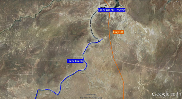
Start: Clear Creek Reservoir
End: There and Back
Permits: None
Wet Suit: Not needed
Shuttle: No
Overview: A very long creek that begins some 100 + miles in the Coconino National Forest. The creek actually acts as the border of the Coconino National Forest and the Apache-Sitgreaves National Forest. The canyon offers some moderate sheer walls and refreshing pools to swim through in many sections. Although the canyon itself isn’t so high a flash flood through here would prove deadly with very few places of escape. The rout begins almost at the tail end of Clear Creek as it enters the Clear Creek Reservoir and goes upstream as long as you desire.
Approach: From Winslow head south on Hwy 87 to Hwy 99. After 4.43 miles you will cross Clear Creek Reservoir. Continue south a total of 5.27 miles from Hwy 87 where you’ll discover a dirt road on the right. There are many dirt roads that split off from the Hwy 99 after the Clear Creek Reservoir crossing. At 5.27 miles from Hwy 87 you’ll find a dirt road that’s 0.3 miles from where you’ll want to park. View my Google map for a better idea. To get down into the gorge simple follow the drainage to the south of the road. Once you hit the gorge of Clear Creek skirt the cliff’s edge upstream past a second drainage. From there you should find a scramble rout to the floor of the canyon.
View Clear Creek.kmz in a larger map